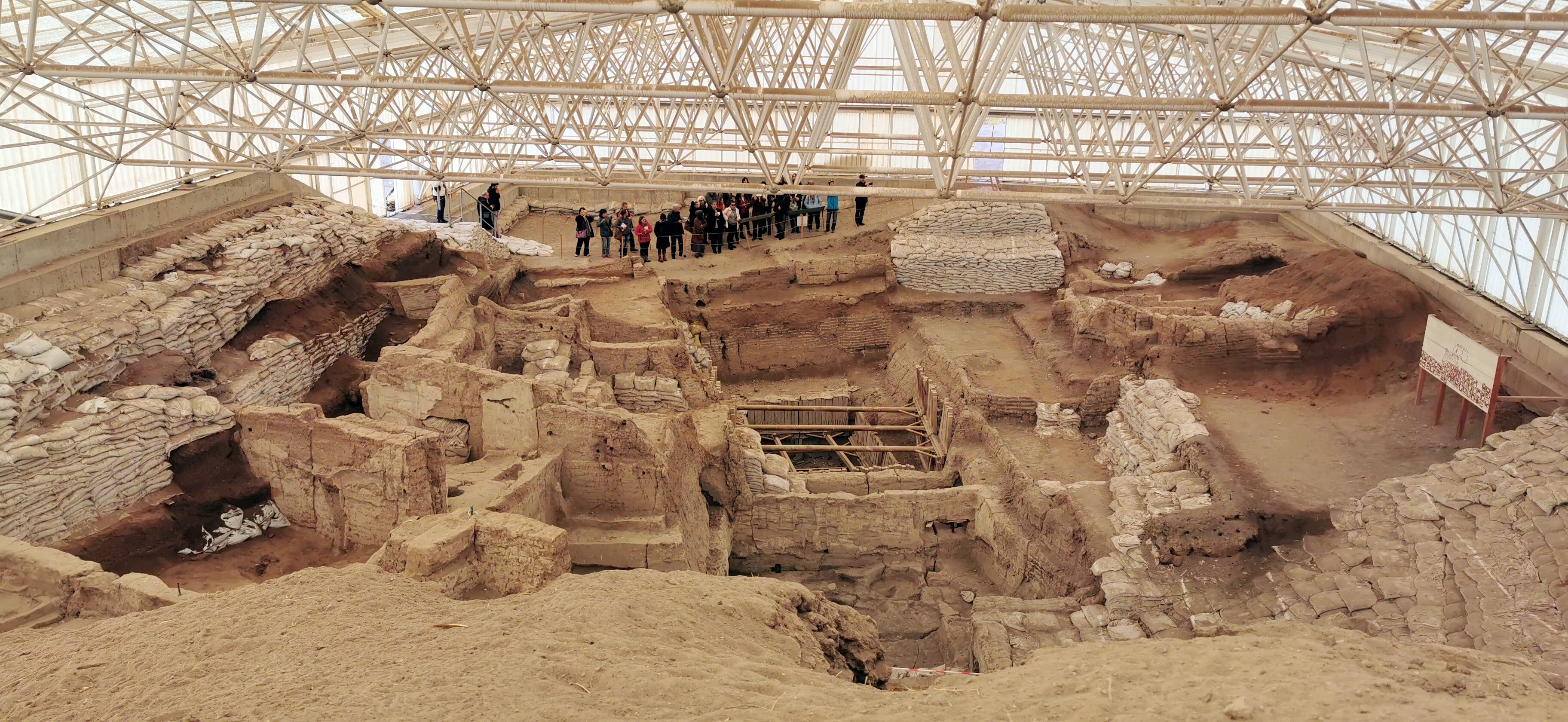
Çatalhöyük is a massive Neolithic and Chalcolithic proto-city settlement in southern Anatolia, which existed from approximately 7500 BCE to 6400 BCE. It is one of the best-preserved examples of early human social organization, characterized by a unique urban layout where houses were built directly against one another without streets, requiring residents to access their homes via roof openings.
The site provides significant insight into the transition from nomadic hunter-gatherer lifestyles to settled agriculture. Excavations have revealed complex domestic architecture, elaborate wall paintings, and evidence of sophisticated ritual practices, marking it as a pivotal location for understanding the development of human society and sedentary life.
Key Facts
- Materials
- Mud-brick, Timber, Plaster
- Civilization
- Neolithic Anatolian
- Accessibility
- Accessible via walking paths; some areas restricted for research
- Date(s)
- 7500 BCE - 6400 BCE
- Condition
- Active archaeological site with protected excavation shelters
- Original Function
- Residential settlement
- Key Figures
- James Mellaart, Ian Hodder
Establishment
7500 BCEThe settlement was established on the Konya Plain, likely chosen for its proximity to the Çarşamba River, which provided fertile land for early cereal cultivation and animal husbandry.
Urban Development
7500 BCE - 6400 BCEThe site grew into a dense, multi-layered settlement. The unique 'honeycomb' architecture evolved, where houses were continuously rebuilt on top of previous foundations, creating a massive artificial mound or 'höyük'.
Modern Discovery
1958 CEThe site was first discovered by James Mellaart in 1958. His initial excavations in the 1960s revealed the site's immense archaeological importance, particularly its well-preserved wall art and burial practices.
Contemporary Research
1993 - PresentThe Çatalhöyük Research Project, led by Ian Hodder, began in 1993. This phase utilized modern scientific methods to analyze social organization, diet, and environmental changes, leading to the site's inscription as a UNESCO World Heritage site in 2012.
Cultural Significance
Çatalhöyük is fundamental to the study of the Neolithic Revolution. It challenges traditional views of early human social structure by demonstrating that large, dense populations could exist without centralized authority or social stratification. The site's symbolic art, including bull motifs and figurines, suggests a complex belief system that integrated daily domestic life with ritualistic practices.
Today, the site serves as a global reference point for the origins of urbanism. It remains a focal point for debates regarding the role of gender, social equality, and the human relationship with the environment in early sedentary societies.
Interpretive Notes
Scholarly debates and areas of uncertainty
There is ongoing debate regarding the nature of social hierarchy at the site. While some scholars argue for an egalitarian society based on the uniformity of house sizes, others point to differences in burial goods and interior decorations as evidence of emerging social differentiation. Additionally, the exact function of the 'shrine' rooms remains a subject of intense academic discussion.
Visiting Information
Entry Rules
Open to the public. Visitors must follow marked paths and are prohibited from entering active excavation trenches without authorization. No specific dress code, but modest attire is recommended.
Best Times to Visit
Spring (April-May) and Autumn (September-October) offer the most temperate weather for exploring the open-air site.
Photography
Personal photography is permitted. Professional or commercial photography requires prior authorization from the Turkish Ministry of Culture and Tourism.
Nearby POIs
1 shownSources & Further Reading
- [1]On the Surface: Çatalhöyük 1993-95 — Ian Hodder. McDonald Institute for Archaeological Research (1996)View
- [2]The Leopard's Tale: Revealing the Mysteries of Çatalhöyük — Ian Hodder. Thames & Hudson (2006)
Key Facts
- Materials
- Mud-brick, Timber, Plaster
- Civilization
- Neolithic Anatolian
- Accessibility
- Accessible via walking paths; some areas restricted for research